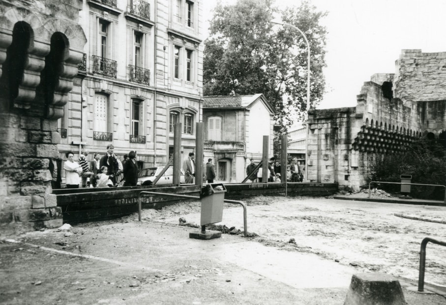
Avignon.Flooding of the Rhône in Avignon. Temporary flood barriers at Porte Saint-Dominique.
In 1993 – 82Fi47
A river city located at the confluence of the Durance, Avignon has long lived with floods and inundations as part of its daily life and history, with at least one significant annual rise in water levels (due to snowmelt and autumn rainfall). This is reflected in the city’s toponymy—Sources district, rue de l’Arrousaire, Baigne-Pieds neighbourhood—as well as in the many cast-iron plaques that remind passers-by of the water levels reached during the most devastating floods.
Painters have immortalised striking scenes, and photographers—beginning with Édouard Baldus in 1856—have produced images of these events which, beyond documenting dramatic climatic episodes, often serve to trace the transformations of the urban landscape.
The complete preservation of Avignon’s ramparts owes much to their role in protecting the city from flooding. The photograph presented here was taken in 1993 by Jean Mazet, a surveyor, collector, and passionate enthusiast of history and photography. It bears witness to the historic function of the ramparts in holding back floodwaters and documents the protective structures—known as batardeaux—installed “since time immemorial” at the city gates to safeguard the buildings within the walls.
Since the second half of the 20th century, major alterations to the hydrographic networks indirectly linked to the Rhône—along with their regulation and the construction of dams—have made Avignon highly dependent on upstream decisions in the event of exceptional rainfall.
Aure Lecrès
Avignon’s Archives
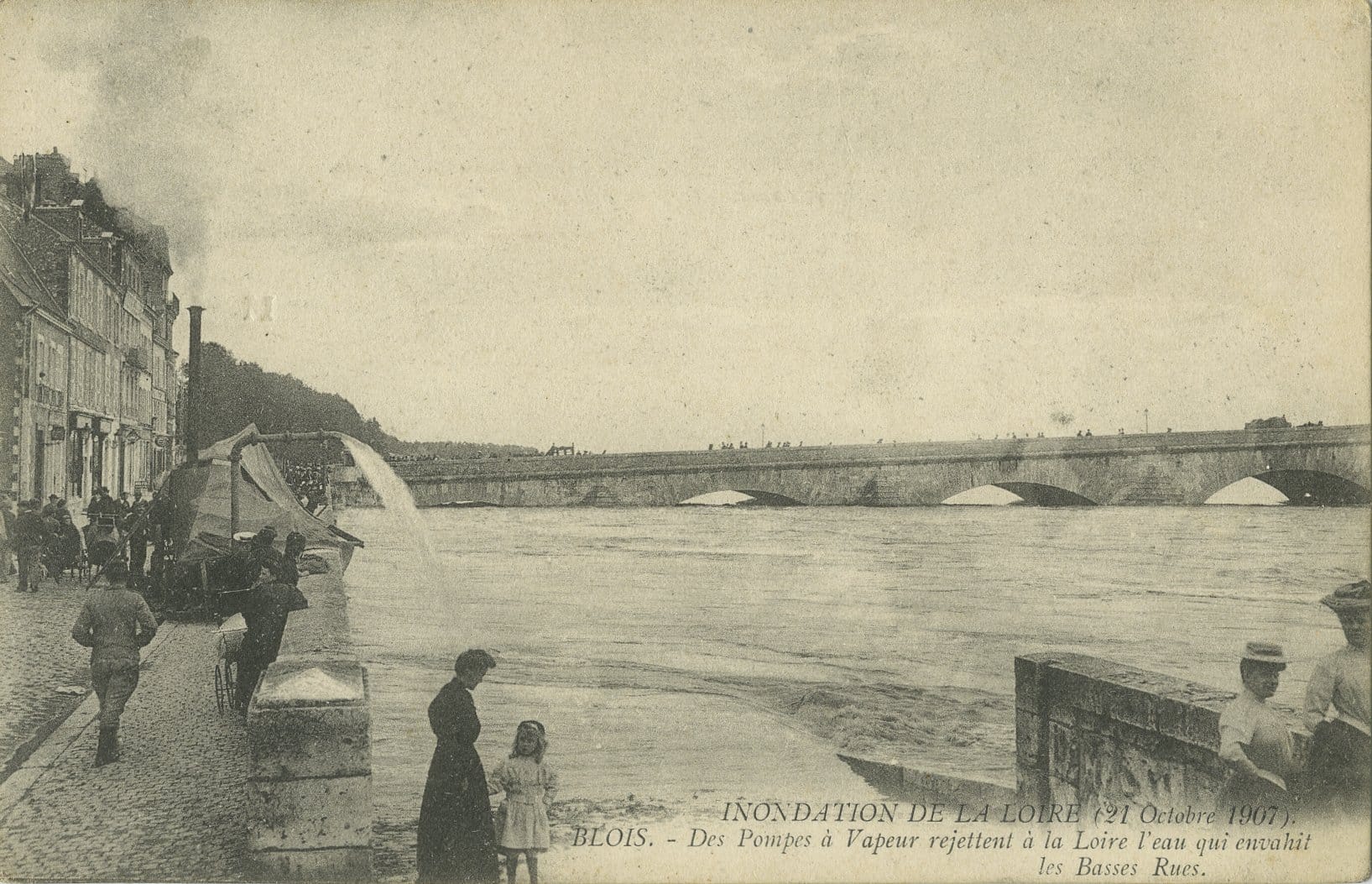
Blois.
Flooding of the Loire.
October, 21st 1907 – FRAC41018_5Fi_0756
In Blois, as in all cities built along rivers, nature has repeatedly asserted its power. In the 19th century, the town experienced nearly twenty floods, with the most severe occurring in 1846, 1856 and 1866. Even earlier, the royal river regularly overflowed its banks, particularly in the Vienne district.
The postcard shown depicts the Loire in flood on 21 October 1907, a reminder that at the beginning of the 20th century, humanity still had limited control over climatic hazards. The scene is striking for the contrast between the residents in the foreground and the moving mass of water, which rose to as much as 5.65 metres. In the middle ground, a steam pump can be seen draining water from the lower streets, while onlookers watch the river continue to rise. In the background, the Jacques-Gabriel Bridge withstands the pressure of the Loire.
This document is preserved at the Shared Archives Service of the City of Blois, Agglopolys and the CIAS of the Blaisois. Catalogued under reference 5Fi, it comes from a bequest made in 2014 by Miss Ginette Chantepie. This donation, incorporated into series 19 Z, also includes press clippings on the history of Blois (1960–2014) and a collection of slides depicting various locations in the city (1965–1982).
Private archives are a valuable resource: they complement and shed light on public collections, offering a more nuanced understanding of local history.

La Rochelle.
Circa 1911-1912 – 5 Fi 1824
In the aftermath of a storm, local residents discover this fishing boat washed ashore along the wooden spur of La Croix, a small breakwater jetty protecting the recently sanded La Concurrence beach. In the years 1911–1912, the Municipal Council, working in close cooperation with the Chamber of Commerce, was considering an ambitious programme to improve and expand the Port of La Rochelle-Ville.
Beyond its purely commercial dimension, this programme also addressed issues of safety and protection. Among the proposals was the construction of a new tidal harbour that would allow the entire fleet to take shelter in the event of a storm. The existing harbour, located in the old port, was insufficient at the time—as this document clearly demonstrates.
This postcard comes from the Camille Robreau collection, named after the collector who assembled it. Acquired by the Municipal Archives of La Rochelle in 1988, the collection brings together 4,653 postcards dating from 1880 to the 1970s.
Beyond its value for documenting specific events—such as this climatic episode—the collection is a rich source of information on the history of the city as a whole, including its urban and architectural development as well as its economic activities.
Summary
Flooding poses a serious threat to cities, their inhabitants and their infrastructure. Throughout history, flood-prone areas have therefore had to develop various systems to limit the damage caused by rising waters. Their implementation is often closely linked to urban planning.
To effectively manage a threat of this scale, protective measures must be carefully designed and put in place in advance. This is the case, for example, with the batardeaux in Avignon, which make use of the city’s historic walls to block the advance of floodwaters. During the 19th and 20th centuries, as public authorities became increasingly involved in the management of natural disasters, safety concerns gained greater importance. This can be seen in the example of La Rochelle, where plans were developed to extend the tidal harbour in order to protect vessels. With the Industrial Revolution, flood management also took on a new form: technology. Steam-powered machines, as seen in Blois, could be brought directly to disaster sites, enabling a more effective response to natural hazards.
Through these archival documents, we can observe the means developed over time to confront flooding. By offering a glimpse into another era, they reveal the evolution of these techniques and help us understand the external factors that shaped them—thus tracing part of our shared history.